Bryan Norcross: A lower chance of development of the tropical systems in the Atlantic and Caribbean
On the current schedule, the disturbance will be near or north of Puerto Rico and the nearby islands about Friday, then slowly continue to the west toward the southeastern Bahamas or perhaps near Haiti or eastern Cuba.
Bryan Norcross: A lower chance of development of the tropical systems in the Atlantic and Caribbean
There is no threat to Florida or the southeastern U.S., but everyone on the northeastern Caribbean islands should stay informed just to be sure Invest 94L doesn't misbehave.
Updated at 10 a.m. ET on Wednesday, Oct. 16, 2024
The tropical disturbance labeled Invest 94L still has a chance to develop into a tropical depression before it reaches the waters near or just north of the northeastern Caribbean islands. However, most computer forecast models have backed off the idea that the system will maintain much organization as it moves near the islands.

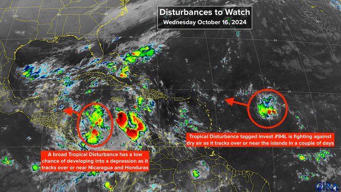
Satellite imagery shows two tropical disturbances facing barriers to development.
(CIRA / RAMMB)
The disturbance still has a reasonably well-defined but broad circulation, but dry air has not allowed thunderstorms to organize and persist, which in turn would tighten the circulation – the requirements for the tropical depression designation.
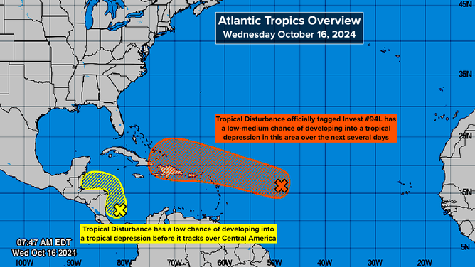
The National Hurricane Center has dropped the disturbance's chances into the low-medium range as, increasingly, the computer forecasts have pulled back from predicting that the disturbance will develop.
On the current schedule, the disturbance will be near or north of Puerto Rico and the nearby islands about Friday, then slowly continue to the west toward the southeastern Bahamas or perhaps near Haiti or eastern Cuba. It's not clear that the system will be identifiable by that time, but it will draw tropical moisture over the mountainous islands, bringing the possibility of flooding and mudslides.
If the disturbance survives past the Dominican Republic, it's going to run into extremely hostile upper winds and a strong cold front that will have pushed into the Bahamas. At that point, the system will likely either dissipate or be absorbed into the front.
There is no threat to Florida or the southeastern U.S., but everyone on the northeastern Caribbean islands should stay informed just to be sure the disturbance doesn't misbehave.

(National Hurricane Center)
In the southwestern Caribbean: Another broad disturbance is forming off the coast of Nicaragua. Most likely, it will move inland over the mountains of Nicaragua and Honduras. There is some chance, however, that it will loop north so that it stays over the water and impacts Belize or Mexico.
In that second scenario, it could develop into a tropical depression or perhaps a storm. The National Hurricane Center has the chance of at least a depression developing in the low category.
The biggest threat from the system appears to be heavy rain causing flooding and possible mudslides over Central America.
Looking ahead: Hostile upper-level winds are forecast to continue over the northern Gulf of Mexico and Florida for the foreseeable future. That will keep any potential tropical systems away, and beyond the two low-odds disturbances in the Atlantic and Caribbean, nothing appears in the offing.
