Bryan Norcross: Flood threat continues in Carolinas before Debby's moisture heads north Friday
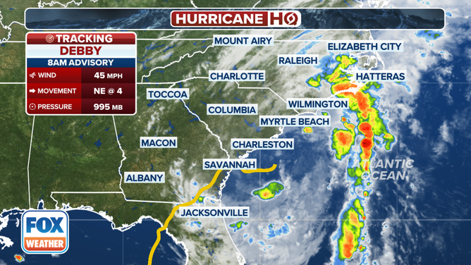
The center of Debby's circulation will slowly make its way to North Carolina by Thursday. The focus of the new rain should move along with it, but it will take time for the water that falls at higher elevations to drain through the Lowcountry and the coastal plain.

FOX Weather is your Hurricane HQ.
(FOX Weather)
Updated at 9 a.m. ET Wednesday, August 7, 2024
Tropical Storm Debby is drifting just offshore of the South Carolina coast. There are two dangerous parts to the storm.
On the east side, intense bands of thunderstorms are rotating into South and North Carolina. The moisture is being pushed into the South Carolina Midlands and the North Carolina Piedmont, all of which will eventually find its way downhill toward the Atlantic.

Tropical Storm Debby is drifting just offshore of the South Carolina coast.
(FOX Weather)
Streams and creeks and rivers will overflow their banks, aggravating the flood situation in areas with high water at lower elevations near the coast. In addition, where the winds are blowing onshore, storm surge from the Atlantic will push into the harbors and inlets, keeping water from the rivers from flowing out to sea. Again, in the areas affected by the surge, the flooding will be worse.
The center of Debby's circulation will slowly make its way to North Carolina by Thursday. The focus of the new rain should move along with it, but it will take time for the water that falls at higher elevations to drain through the Lowcountry and the coastal plain. So the flood threat will not immediately end when Debby pulls away on Friday.
The Bermuda high over the Atlantic has not reached far enough west so far this week to grab Debby and push it north. However, it has been streaming tropical moisture into the mid-Atlantic and Northeast. That moisture, combined with an old front, has produced several rounds of strong thunderstorms, which will continue today over the mid-Atlantic, although with less intensity than yesterday’s storms.
Another front will move in from the northwest toward the end of the week, driven by a dip in the jet stream that will grab Debby and yank it north.
Debby will die out, but its moisture combined with the front is likely to make a nasty combination Friday into Saturday along much of the I-95 corridor and inland to the higher terrain. The rain could be quite heavy since it will be enhanced by Debby's tropical moisture. Stay informed and stay aware of flooded roadways.
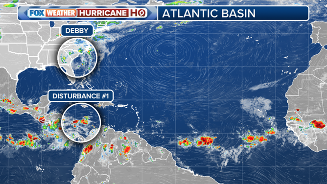
Elsewhere in the tropics, a tropical disturbance moving through the Caribbean will move into a slightly more conducive atmospheric regime when it gets to the southern Gulf of Mexico. The National Hurricane Center is giving it a very low chance of developing.

A tropical disturbance moving through the Caribbean will move into a slightly more conducive atmospheric regime when it gets to the southern Gulf of Mexico.
(FOX Weather)
In any case, high pressure over Texas and the Southeast should keep it well to the south of the U.S.
In the eastern Atlantic, disturbances continue to move off Africa, but there are no concerns at this time. Saharan dust and dry air continue to dominate the tropical Atlantic.
On average, the dust season ends around the middle of August. We'll see.