Bryan Norcross: Remembering Hurricane Andrew on the date of impact while the 2024 Atlantic tropics stay quiet
Hurricane Andrew happened a long time ago, or just yesterday. It depends on if you were there.

FOX Weather is your Hurricane HQ.
(FOX Weather)
On this day 32 years ago, Hurricane Andrew left a trail of unimaginable destruction and hardship as it screamed across a 20-mile-wide swath of southern Dade County, Florida. The outer edge blew through the condo canyons of Brickell Avenue in downtown Miami, sucking furniture out of high-rise apartments and terrorizing residents across South Florida.
Unimaginable things happened. Palm trees were impaled by flying 2x4s and plywood. Cars flipped in their garage. Twenty-five to thirty thousand homes and businesses were destroyed, and 100,000 more were damaged, mostly between 5:00 and 7:00 AM.
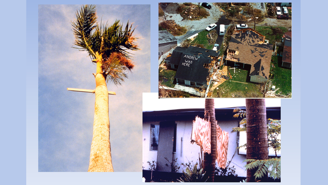
Impaled palm trees. Aerial view of destruction.
(NOAA / FOX Weather)
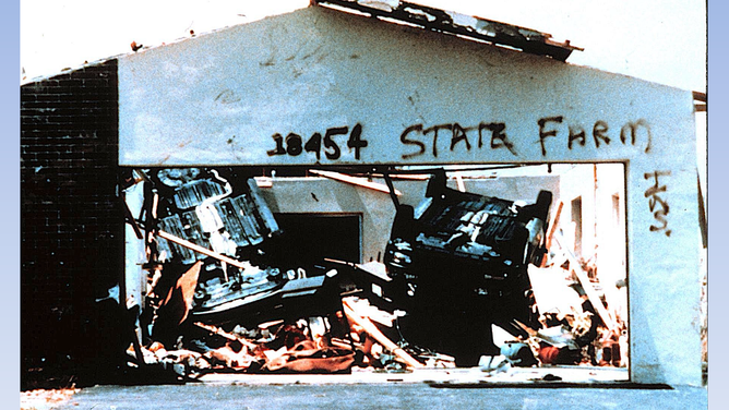
Flipped over vehicle inside building.
(NOAA / FOX Weather)
The Miami Herald's headline the next day was "Destruction at Dawn." But it was more than that. It was devastation as far as you could see from a helicopter. Most of the catastrophe zone was inland, so people were at home. But homes were gone or maybe had one room where the roof held out most of the torrential rain that fell that following week.
There was no power, no water, and no communications in most neighborhoods. And there were looters. That week was beyond a nightmare.
In the WTVJ studio in downtown Miami, as midnight turned into 1:00 and 2:00 AM that Monday morning, the inevitability of a worst-case impact on suburban South Dade County became clear. Over the next hour, I had the two best ideas of my life. I remembered a story by L.F. Reardon describing how he used a mattress to help protect his family in the Great Miami Hurricane of 1926, and I thought we should move off the anchor desk to a storage closet/bunker - a safe spot on the edge of the studio.
I found out later that these ideas motivated people to take action that made a difference. They were safe under the mattress when their house came apart. Or they thought, if those TV people are moving to a storage closet, they're not kidding. This is serious. Let's do that too. A couple hours later, the bathroom door was the only thing between the family and Andrew raging through the house.
A lot of what happened in our hurricane coverage was pre-planned. But these ideas were born from my straining my brain to figure out what we could do or say that we hadn't done or said through two days of long hours of coverage.
At about 3:15 AM, the first strong band of wind was whipping at the coast in South Dade. At 4:00 AM, the eyewall was coming ashore. This was it. At 5:05 AM, the center of Andrew's eye made landfall on the bayfront near Homestead - 20 miles south of downtown Miami.
Andrew ripped and roared on a path just north of due west. It sped across South Dade at about 20 mph, damaging or destroying every building in its path. In essence, it was a giant 20-mile-wide top-end tornado. An EF-5 tornado has wind gusts over 200 mph. That was Hurricane Andrew.
The National Hurricane Center was on the 6th floor of a 12-story building in Coral Gables. The Miami Radar was on a pedestal structure on the roof, which put it about 15 stories up.
The winds and the NHC steadily increased starting at about 3:00 AM, measured by a National Weather Service anemometer mounted up near the radar. By 4:15 AM, the gusts at the top of the building were over 100 mph. After 4:30 AM, the building started to shake. A window blew out inside a closed shutter. The last radar image we saw at WTVJ was at 4:35 AM when our microwave antenna that transmitted the data and video to our studio likely blew off the building.
On the left here, you see what our viewers who still had power saw on the air.
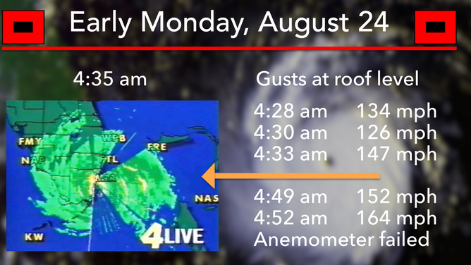
Radar and wind gusts.
(FOX Weather / FOX Weather)
The last recorded radar scan at the NHC was apparently at 4:38 AM. University of Miami researcher Brian McNoldy maintains a fantastic website where he archived the Andrew radar loops plus every other significant hurricane since. You can see them all at this link.
The highest gust they measured was 164 mph at 4:52 AM, but the peak gust was likely a bit higher. The arm that held the anemometer failed. The device was found tipped over, one of its spinning cups missing.
A few minutes before 5:00 AM, a loud boom shook the NHC's building to its core. Hurricane Center Director Dr. Bob Sheets told me later he immediately knew what happened. The massive radar unit blew off its pedestal and crashed onto the roof.
These incredible events were documented by someone on the staff of the local National Weather Service office, which was co-located with the Hurricane Center. It was probably the radar operator. Here's the wind trace and the comments from that fateful night.
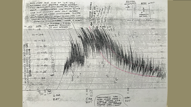
Wind trace.
(FOX Weather / FOX Weather)
Notice that the times printed on the scale are in Eastern Standard Time. The wind measurements occurred one hour later on the clock - between 4:30 and 5:30 AM Eastern Daylight Time - times you see written in. The operator noted that the "radar antenna failed" at 4:54 AM. That was probably when it careened onto the roof. Part of the radar's golf-ball dome was found in the pool of the Holiday Inn next door.
The stunning winds were not just at roof level. Cars flew around the parking lot. And this all happened at the edge of the eyewall. A few miles south and west in the heart of the storm, it was so much worse.
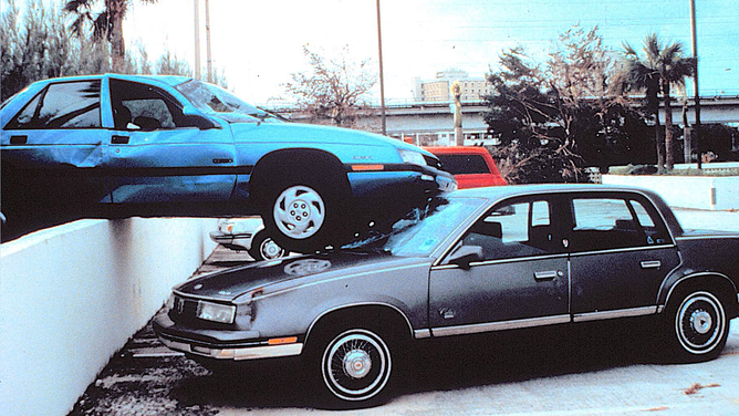
Cars in a parking lot.
(FOX Weather / FOX Weather)
Songs and blogs and books have been written about what happened that night. I wrote one, "My Hurricane Andrew Story," which you can still get on Amazon if you like. But no book or picture can describe what the people under the core of the storm went through.
The enduring lesson of Hurricane Andrew is that the worst does happen.
After the storm, Miami-Dade County upgraded the building code, which today is the standard for hurricane defense worldwide. Buildings away from the water built to the modern code should survive and be inhabitable, even after a storm like Hurricane Andrew.
But that day and in the weeks that followed, it was hard to imagine that any good could come from Andrew. Those with money moved out of South Dade. Many never returned. Those that couldn't, suffered.
The military finally arrived, secured the storm zone, and began feeding the stranded. The soldiers did heroic work, but it was six days before they were set up and ready to help. Those six days were hell on Earth.
Today, South Dade is thriving. The population is exploding. Construction is nonstop and up to modern Miami-Dade standards. But it was a long road with many potholes and heartaches between then and now.
Hurricane Andrew happened a long time ago, or just yesterday. It depends on if you were there.
THE 2024 TROPICAL ATLANTIC mercifully remains calm. No development is expected for the rest of August.
inhabitable,, Tropical Storm Hone will track near the Big Island of Hawaii today. Strong winds will lash the south half of the island, especially around the headlands, over the gaps in the mountain ridges, and downslope on the west side. Flash flooding will be a threat from 5 to 10 inches of rain on the windward and southeast-facing slopes.
Stay well-informed if you’re in the storm zone.